Crowders Mountain PoInts of Interest
Orienteering - Advanced Course
Main Index
Orienteering Index
Crowders Mountain State Park
Permanent Orienteering Course Instructions
The map.
Scale: 1:10,000. one centimeter on the map = 100 meters on the ground.
Contour interval: 5 meters, every time you cross a contour line you either
gain or loose 5 meters elevation.
Magnetic North Meridians: vertical black lines pointing towards the top of
the map or north.
Color coding:
Black: man-made objects and rock features
Blue: water, lakes and streams
Green: ground level vegetation, the darker the green the slower and more
difficult the travel.
Yellow: Several shades of yellow indicate varying degrees of open land from
mowed grass to rough open with scattered trees.
Brown: contour lines and earthen features like gullies, ditches, pits and
rootstocks.
White: the white areas are open forest with very little or no ground
vegetation.
Red: Start triangle and control locations and numbers.
Take a minute and familiarize yourself with the legend. Identify some of the
features of the map.
The Clue Sheet on the back of the map gives control feature descriptions.
Orienting the map.
Stand at the flag pole in front of the visitor's center, facing the parking
lot. You are standing in the middle of the red start triangle. Hold the map
flat with your compass on top. Notice the north end of the magnetic needle
is pointing to your right. Rotated the map and compass until the north
meridians, four vertical black lines on the map, are aligned (parallel) with
the compass needle and the northern end points toward the top of the map.
Now the map is oriented and matches what you see on the ground. If you look
across the parking lot you see an open field. The open field is the yellow
area on the map shown just beyond the parking lot. As you travel from
control to control, you should always keep the map oriented, reading the map
and anticipating what you should see on the ground.
Courses: Visit the control points in numerical order.
White: Beginner course, controls mostly on or visible from trails. Length
2.5 km.
Control sequence: 7,5,19,17,16,14,13
Yellow: Beginner course, longer and more controls than white. Length 3.9 km.
Control sequence: 7,15,17,18,6,21,4,3,2,9
Orange: Intermediate level course, a mix of easy and difficult controls.
This course requires off trail, cross country travel. The orienteer must
utilize land features such as streams and reentrants and compass bearings to
navigate to the control points. Length 4.9 km.
Control sequence: 6,15,17,20,23,3,8,1,10,11,12.
This suggested course sequence is just a guide to get you started. You can
mix and match the controls and order visited to design your own courses,
depending on your desired level of difficulty. Easier controls are on or
near trails. Harder controls are farther off trails. Permanent orienteering
courses provide different courses options to continue the challenge and
practive navigation. For further information on Orienteering or to
participate in Orienteering Meets visit.
Start
|
|
1
|
Boulder
|
2
|
Re-entrant
|
3
|
Boulder Field
|
4
|
Re-entrant
|
5
|
Path Junction
|
6
|
Re-entrant |
7
|
Path Crossing Stream
|
8
|
Re-entrant
|
9
|
Path crossing Path
|
10
|
Boulder
|
11
|
Re-entrant Junction
|
12
|
Earth Bank North Side
|
13
|
Footbridge Northwest Side
|
14
|
Vegetation Boundary Northeast Edge
|
15
|
Cliff West Foot
|
16
|
Gully Upper Part
|
17
|
Cliff North Foot
|
18
|
Root Stock Between
|
19
|
Hill On Top
|
20
|
Marsh Southwest Side
|
21
|
Stream Junction
|
22
|
Spur Northeast Part
|
23
|
Boulder East Side
|
End
|
|
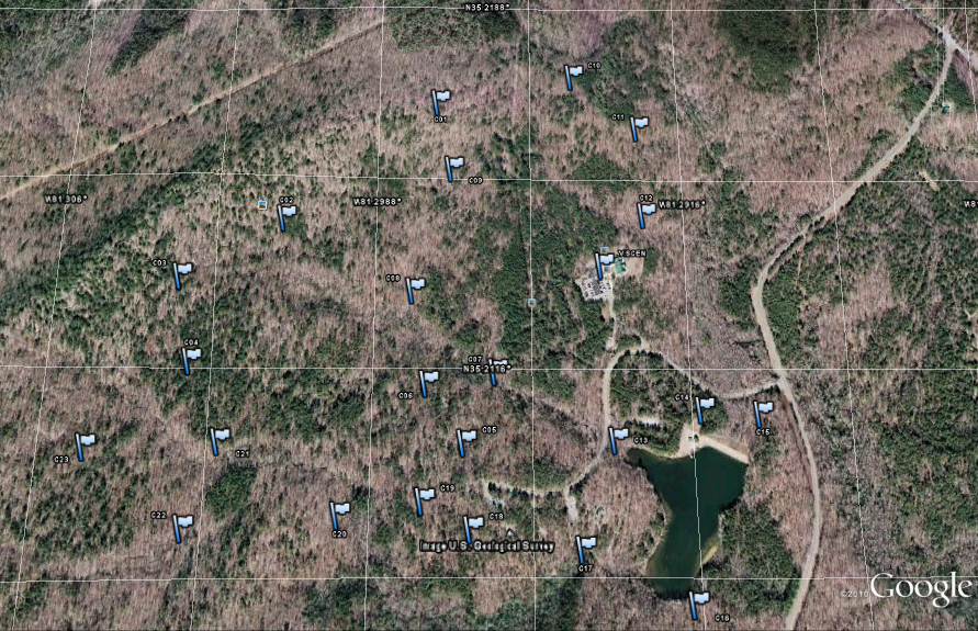
Advanced Orienteering Course
.gpx file
VisitorCenter : lat="35.213245" lon="-81.293506" ele="291.486298"
C01 : lat="35.216393" lon="-81.297321" ele="298.353638"
C02 : lat="35.214133" lon="-81.300872" ele="281.347229"
C03 : lat="35.213004" lon="-81.303126" ele="292.382080"
C04 : lat="35.211454" lon="-81.302821" ele="274.506195"
C05 : lat="35.210016" lon="-81.296666" ele="278.924652"
C06 : lat="35.211060" lon="-81.297517" ele="263.304779"
C07 : lat="35.211276" lon="-81.295970" ele="270.195435"
C08 : lat="35.212773" lon="-81.297866" ele="262.350525"
C09 : lat="35.215111" lon="-81.296994" ele="276.367401"
C10 : lat="35.216993" lon="-81.294127" ele="282.143890"
C11 : lat="35.215986" lon="-81.292553" ele="260.750671"
C12 : lat="35.214249" lon="-81.292454" ele="252.630188"
C13 : lat="35.210054" lon="-81.293287" ele="249.312454"
C14 : lat="35.210597" lon="-81.291333" ele="249.194550"
C15 : lat="35.210523" lon="-81.290038" ele="253.132401"
C16 : lat="35.207303" lon="-81.291715" ele="254.844589"
C17 : lat="35.208197" lon="-81.294077" ele="250.858002"
C18 : lat="35.208541" lon="-81.296508" ele="268.502411"
C19 : lat="35.209019" lon="-81.297563" ele="279.754944"
C20 : lat="35.208772" lon="-81.299398" ele="277.213989"
C21 : lat="35.210034" lon="-81.302092" ele="263.971619"
C22 : lat="35.208566" lon="-81.302731" ele="269.754181"
C23 : lat="35.209941" lon="-81.304955" ele="276.700653"
---
---